The coalfield is different
from all other British fields, with the exception of its
small neighbour the Forest of Dean, in that it is a true basin of wholly exposed
Coal Measures. Indeed, the South Wales field may be likened roughly to a pie
dish elongated from east to west and with a rim which is formed of Millstone Grit
and Carboniferous Limestone, usually flanked by still older rocks. In the centre of
the pie dish, there is a three-fold sequence : a Lower Series of coal-bearing
rocks, then a thick sandstone usually without coal (Pennant Grits) and then an
Upper Series of Coal Measures (Fig 1).
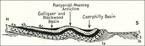
Fig 1 Section
through eastern region of South Wales Coalfield
1a, Silurian and lower Old Red Sandstone; 1b, upper Old Red Sandstone; 2, Carboniferous
Limestone; 3, Millstone Grit; 4a, lower Coal Series; 4b, Pennant Grit; 4c, upper Coal Series; 5,
Mesozoic and later rocks.
One would expect the
Coal Measures to be at the greatest depth in the centre of
the pie dish. That is not the case because of an important upfold, also with an
east and west direction, which brings the Lower Coal Series comparatively near
the surface even in the centre of the field, and which results in the distribution of
the Upper Series usually in two distinct basins in the north and south,
respectively, of the main basin. The whole field has a length from east to west of
about 90 miles. Its greatest width, 16-17 miles, is in the old county of
Glamorganshire (Fig 2). An average width of about 15 miles is maintained as
far as Swansea Bay. Westwards the coalfield narrows and in the western part of
Pembrokeshire it is scarcely three miles across. If one includes the portions
covered by the sea in Swansea Bay and Carmarthen Bay the area of the
coalfield is over 1,000 square miles.
The topography of the
greater part of the coalfield is particularly characteristic in
that deep transverse valleys have been, and to a great extent still are, the main
factor determining the location of collieries, villages, and towns. In the early days
levels were opened up along these steep-sided valleys, and the first mines were
thus with natural drainage to the valleys. Shafts were usually sunk in the valleys
to avoid passing through, an unnecessary thickness of the Pennant Grit or other
barren rook. Between the deep valleys are large tracts of moorland at a
considerable elevation above sea level; and from the surface of these wide
open moorlands it was often impossible to see a colliery and to realise that one
was in the heart of a coalfield.
Turning to details
in the geological structure, apart from the central anticline
which lies in the middle of the main synclinal basin, there are other similar
anticlines which thus bring the lower coals within mineable reach. Then the
whole of the main basin is crossed by a pronounced and remarkably regular
series of faults trending in general from north-north-west to south-south-east.
Some of these form trough faults with " troughs " of Coal Measures let down
between them, but on the whole they throw westwards, so that it is in the
neighbourhood of Swansea that the lower coals are found at their greatest
depth. In fact they are depressed below 4,000 feet which could not be mined.
Then there is another and very important series of faults, the faults trending west-
south-west and commencing particularly at the Vale of Neath and then found
with great intensity further westwards. Important rivers, notably the Neath, find
their way along the fault lines towards the sea. Away in the north- west of the
coalfield and in Pembrokeshire folding and faulting have been very intense ;
frequently the beds are overfolded and there are great thrust faults, and the
whole structure is such as to render mining difficult.
The development of
the South Wales coalfield has been influenced to a very
large extent by the high quality and the variety of the coal. Whilst bituminous
coals are present in quantity there are the well-known steam coals and
anthracites, both of which are characterised by a high percentage of carbon and
a low percentage of volatile matter. In many South Wales coals, in addition, the
ash is very small in amount. This is particularly so in the anthracite. Whilst
bituminous coals commonly have an ash content of five to ten per cent., that of
the steam coal of South Wales is frequently under four per cent., and in the case
of the anthracite it is only about one per cent. Anthracite is found in the detached
portion of the coalfield, in Pembrokeshire, and also in the north-western part of
the main field from the Gwendraeth Valley approximately as far as the head of
the Vale of Neath. The seams are in the Lower Coal Series. Eastwards and
southwards towards Pontypool and towards Bridgend the anthracite seams
change in character, each seam passing first into a steam coal and then into a
bituminous coal. Thus towards the south crop of the coalfield from Swansea to
near Newport the seams in the lower part of the Coal Measures are bituminous,
whilst between this area and the anthracite district they are mainly steam coals
of various grades. It is particularly around Aberdare and in the Rhondda Valley
that the most famous of the steam coals have been mined. The coals of the
Upper Series are generally bituminous coals. Broadly speaking, about 50 per
cent, of the coal available in South Wales was steam coal, about 30 per cent,
bituminous, and about 20 per cent, anthracite.
Coal was undoubtedly
worked in the South Wales field as early as the thirteenth
century, whilst towards the end of the sixteenth century it was being used for the
smelting of copper at Neath. For some considerable time most of the working in
the northern part of the field was done by what is called " patching "—digging
the nearly horizontal seams in open "workings. This was succeeded by
workings in bell pits, the shallow pit being dug near the outcrop of the seam, and
workings being made outward from it in all directions until it was considered
unsafe to proceed further. As the collieries and workings became deeper,
mining became unpopular ; so that in the seventeenth, century it was not
uncommon for criminals to be pardoned by the king on condition that they would
work for five years in the mines. In the latter part of the eighteenth century coal
began to be used generally in tlie iron industry and there followed the great
expansion in the export trade in coal.
A detailed map of South
Wales will show the way in which the valleys in the
south-east of the field join and lead to two main centres—Newport and Cardiff.
The export trade of Newport developed particularly after the opening of the
Monmouthshire Canal, and the quantity exported rose from about 10,000 tons in
1798 to no less than 148,000 tons twelve years later in 1809. Some years
afterwards Cardiff developed as an exporting port, but not before Swansea had
attained great importance. Tramways and canals brought the coal to the ports,
and the construction of the Taff Valley railway (completed in 1841} to Merthyr
and Aberdare helped greatly in the development of the export trade, whilst the
opening of the Bute Docks at Cardiff in 1839 was a very important factor. Of the
coal raised in South Wales at the present time, some is used locally, and a
considerable quantity goes to the manufacture of coke for metallurgical works. In
1913, however, no less than 70 per cent, of the total output was exported either
abroad or to other parts of Britain by water. The prosperity of the South Wales
coal industry was thus dependent to an enormous extent on the export trade.
By the 1930s the field
had suffered correspondingly from the diminution in that
trade. Cardiff, Penarth and Barry, were then easily the most important ports and
shipped some 60 per cent, or more of the coal; followed by Newport with about
17 per cent., and then by Swansea (about 11 per cent.) and Port Talbot (about 8
per cent.). The two remaining ports, Llanelly and Milford, handled comparatively
very little. Coal exports from Cardiff amounted to around five million tonnes,
about half the amount that passed through the docks in 1914, when coal
production was at its peak.
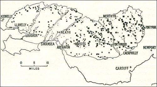
Fig 2 Main collieries
of South Wales Coalfield; 1931