Fig 1 The 1970s rabbit spotters guide
The following
brief history of the island as a human resource is based on the
draft 1992 management plan.
It may be its
accessibility, as well as its size, made Skomer possible as a place
of early human settlement. There is no physical trace of settlement
on the adjacent island of Skokholm before the documented evidence
of Norman occupation (1219 onwards), but Skomer is covered with
very old field enclosures consisting of innumerable tiny
fields and stone-boundaries which edge even the wild fringe
of the steep cliffs. The remains have not been dated accurately but
it is considered that they may belong either to the late
prehistoric Iron Age or to the Romano-British
era.
From the time when
parochial boundaries were established, Skomer has been classed as a
hamlet of St Martin's Parish, Haverfordwest. The first
documented reference to Skomer as part of the Pembrokeshire
rural economy is the 1324 rent for the "pasturage of Skalmeye,
Skokholm and Middleholm". This amounted to
£52.15.0, a considerable sum at the time; "rabbit profits
there" were £14.5.0. In the 14th to 16th centuries
rent was paid for "pasturage" and at this time rabbits were
also of great importance to the island economy.
During the 17th
century corn was grown and the first lime kiln was
built.
The first two
decades of the 1800's saw an extension of corn growing and there is
evidence of five step ploughing on the south facing slopes of North
Valley which date from this time. During this period an injection
of cash by the then owner, Charles Phillips (W.C.A. Phillips)
enabled the farmhouse, the farm buildings and the enclosures to be
substantially improved as a speculative development of his
Pembrokeshire estate for a rental income. The work was completed in
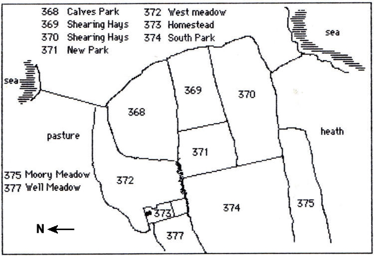
1843. The previous year the Tithe Map and Apportionment for
the island was published. The following sketch map (Fig
2) was made from the Tithe Map of 1842. It depicts the farm
house as a small building in compartment 373 (The
Homestead). The field names come from the Tithe
Apportionment.
Fig 2 Sketch of the Homestead and adjacent fields as depicted in the Tithe Map of 1842
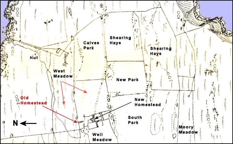
Comparing the Tithe Map with an early Ordnance
Survey map showing th W.C.A. Phillips new homestead and the
layout of its surrounding fields shows the old farmstead is still
there to the northeast of the new farmouse and outbuildings,
which were derelict. The remains of the old farmhouse is now
known as the 'chicken-shed' from the time when it was used for this
purpose by Mike and Roseanne Alexander.
Fig 3 Farmhouse of 1843 in relation to the adjacent fields (from and OS map at the turn of the
beginning of the 20th century.
In the late 1840's
Edward Robinson, one of a new breed of scientific improvers, took
the lease. In due course he passed it on to Captain Vaughan
Palmer Davies, his son- in-law, in 1861. Palmer Davies farmed
the island for thirty years and he left in March 1882 aged 66
years. He had survived a period of considerable agricultural
decline from the late 1870's onwards. His financial
situation throughout this period is unknown, but it is
probably that he was cushioned with wealth he amassed as a
young merchant seaman from his voyages between India and
China.
Meanwhile, the
ownership of the island passed from William Phillips to his son
Charles, who in turn passed to his son William. William
bequeathed Skomer to his nephew Charles Allen, who changed
his name to Charles Allen Phillps, and willed the property to his
son William Charles Allan Philips of St Brides.
W.C.A Phillips
died without children and Skomer became the property of his nephew,
Gilbert Charles Frederick Harries, Rector and Canon of St
David's. Canon Harries sold Skomer, together with
Midland, Gateholm and Grassholm, to Lord Kensington in 1897.
It was then farmed by the tenant from Trehill, one William
Jones.
In 1905 J.J.Neale,
a Cardiff trawler owner and a great friend of Robert Drane who
first described the Skomer Vole, acquired the lease. This was the
turning point for Skomer as he was a keen naturalist and he
was even moved to forbid public landing and photography. Neale died
in 1909 and Walter Sturt, a dentist, bought the island in
1922 but he had no intention of farming. His motivation seems
to have been to improve the health of his asthmatic wife. In
1930 their daughter, an only child, eloped to Gretna Green
with Reuben Codd, their young farm labourer from the
mainland. Reuben was the last to farm the island, which
he did throughout very depressed times up to the 1939 war. He
returned again from 1946 to 1948, when he grew potatoes for the
early Pembrokeshire market, but the logistical problems of ferrying
pickers and potatoes across Jack Sound in rowing boats, led to
failure of the enterprise. The story of the Sturts and Codds,
is told by the local author Roscoe Howells in his book 'Cliffs of
Freedom'.
In 1946 Ronald
Lockley and John Buxton organised a summer long field survey of the
island under the auspisces of the West Wales Field
Society the first such study to be undertaken on the
island and the basis for much of the subsequent biological
recording.
Walter Sturt died
in 1949 and the island was sold in 1950 to Leonard Lee. a Midlands
industrialist (the West Wales Field Society tried to raise the
required money to buy the island at this time but failed), but he
never lived there and the house deteriorated quickly. The roof was
badly damaged in storm in 1954 and never
repaired.
Lee, in due
course, sold Skomer to the West Wales Field Society in 1959 for the
sum of £10,000 and they in turn sold it the same day to the
Nature Conservancy for £6,000 in return for a 21 year lease
renewable for a further period of 21 years. It was declared a
National Nature Reserve in April 1959.