|
|
Home
>
1. Cultural landscapes
>
1.4 Wetland cultures
|
 Previous
Next
Previous
Next 
|
|
|
|
|
'The archaeology record
consists all too often of battered pieces of stone, lumps of
corroded metal, fragments of indestructible pottery, shapeless banks of earth and
amorphous hollows in the ground - axe-heads without handles, whorls without
spindles, hinges without doors and unfurnished rooms.' So wrote Gordon Childe as a
prelude to discussing the importance of ethnography for the archaeologist, but he
could as well have been introducing the subject of wetland archaeology where axe-
hafts and spindles abound, doors and rooms are identifiable and even furniture may
survive. Whereas the loss of organic material is common on dryland sites, in
wetlands where waterlogging followed close on decomposition, even quite fragile
materials can survive for thousand of years. From structural timbers through
composite artefacts such as arrows or sickles to string, nets and fishing lines, the
wetland archaeologist is blessed with an abundance of evidence paralleled only on
sites at the other extreme, in desiccated desert conditions.
The quality of the
evidence for past human activity is also enhanced from wetlands
by the relatively frequent preservation of undisturbed contexts. On a dryland
settlement people trample their rubbish, dogs and pigs scavenge, and weathering
can be severe. Subsequent peoples may plough or dig new foundations, while
burrowing animals contribute to stratigraphic confusion. All these processes and the
many others which reduce the archaeological record can take place in settlements
on wetland margins, but there are times and contexts where water ensures
immediate and undisturbed preservation. In the Somerset Levels, a wooden
trackway built through dense reed swamp about 6000 years ago lay in the wet from
the first, and the chips of wood axed off planks and pegs survived amidst the
Phragmites rhizomes, along with diverseartefactsdropped by the track-builders and
users. Rapid peat accumulation ensured that the structure was waterlogged and
blanketed from an early date. In the circum-Alpine region, prehistoric settlers on the
lake margins dropped their rubbish into the waters, and abandoned their dwellings
when lake levels rose or when fire swept through the settlement and structures
collapsed into the water. Continued sedimentation sealed structures and artefacts
together, and although storm erosion and fluctuating water levels would affect some
sites subsequently, others have survived untouched until the present day. In Florida,
near the present Cape Canaveral, the Indians of 8000-7000 years ago wrapped their
dead in matting bundles and laid them in a shallow pool, to be exposed again only in
the last decade through drainage and housing development. These instances, which
will be examined further below, illustrate the quality of evidence which wetlands can
yield to the archaeologist, a record of the past which is both more complete and less
disturbed than is the dryland norm.
Wetland
archaeology also benefits from the close correlation of environmental
evidence with that for human activity. A lakeside settlement may survive as several
occupation layers, each of which contains pollen and plant macrofossils and perhaps
beetle exoskeletons alongside the human debris, allowing the palaeo-
environmentalist to fit the sequence of environmental change in the vicinity with
episodes of occupation and abandonment of the settlement. Often, much of the
evidence is both artefactual and environmental, and this is particularly true of
structural timbers. An oak plank or post gives information about woodworking
technology, about the nature of local woodlands and about the chronology of the
structure or site it came from. Most of this information comes from tree-ring
analyses, in particular from dendrochronology. The significance of recent
developments in this field is explored further below, for its implications for our
understanding of prehistory are enormous and barely recognized as yet. |
|
However systematically archaeological digs are conducted, many of the prehistorians'
discoveries have been made by chance. Since it is not possible to ransack the face of the
whole world to find stone implements, burial places or other relics, it is to be hoped that when
someone turns up something unusual he will be intelligent enough to inform the specialists.
Such a man was one Olsen, owner of Meilgaard Farm in northeast Jutland. In 1849, having
decided to cut a road through his property, he told the workmen to dig into a mound near the
seashore, covered with trees and brushwood. He believed it to contain gravel, but instead of
gravel the labourers found beneath the top-soil a bed of shells over seven feet thick. Olsen was
not disheartened; suitably pounded and crushed the shells would help to form a solid roadway.
The fact of their being heaped was in no way surprising: piles of empty shells lay scattered all
along the northern coasts of Denmark. But Olsen rubbed his eyes when the workmen brought
out of this layer of shells flint implements, animals' bones and a four-toothed comb of bone,
finely worked and pierced. Olsen sent the comb to the National Museum in Copenhagen.
It was a fortunate decision, for the packet was opened by Jens Jacob Asmussen Worsaae,
a
pioneer of prehistoric research. His interest roused, he began to wonder whether the sporadic
heaps of shells along the Danish coasts might not be the work of primitive man. He
immediately sent out a working party with instructions to make an inventory of the contents of
several well known shell mounds. He himself went to Meilgaard Farm, to talk to Olsen, and had
the good luck to discover in the mound several finds of the greatest interest.
He found that the oyster and mussel shells had been deliberately opened by people
intending
to eat the contents. Flint tools, polished and pointed antlers, bones from which the marrow had
been scraped out, potsherds and cinders were brought out one after the other. All the evidence
tallied: the piles of shells were the remains of meals left in heaps by men who fed upon
molluscs collected at low tide. To what period should they be assigned? In his report Worsaae
wrote cautiously: 'It seems permissible to suppose that this spot was one at which the local
inhabitants of a very early period were wont to meet and have their meals.'
He was to be proved right. In the course of the next few years, especially in the
1890s, Danish
prehistorians studied the problem of the shell mounds and concluded that they dated beyond
all doubt from the Middle Stone Age. In addition to the shells of oysters, mussels and cockles
the mounds included those of crustaceans and snails, the bones offish, ducks and other birds,
particularly sea birds, and those of seals, dolphins, deer, wild pig, lynxes, wolves and smaller
mammals. Some had apparently been gnawed by dogs, from which Johannes Steenstrup
deduced that the inhabitants of the period had owned domesticated canines. The implements
were of stone, horn or antler; none of the sites contained either metal objects or any indication
of the contemporary existence of agriculture or pastoral life.
The Danish kjokkenmoddingen (' kitchen middens')
have an antiquity of seven thousand years,
a period when the North Sea was encroaching on the land and Denmark was finally separated
from Sweden. Nor are those piles unique; the concheros of Spain and Portugal, the sambaquis
of Brazil, the monticules along the coasts of South Africa, Australia and Japan all show that
the inhabitants of the land masses settled everywhere by the sea and fed upon the creatures of
the beaches. It is clear that the people of the shell mounds did not live entirely upon molluscs;
they fished, gathered fruit and berries too, and, like their forbears, hunted in the coastal forests.
The new fact is that they scarcely left the littoral; squatting there they built shelters and huts,
and thus from generation to generation refuse—shells, bones—piled up close by the
settlements. Some of the mounds were raised over a period of a thousand years.
Archaeology has revealed also that men who fished and hunted reached the coast of
northern
Scandinavia and settled along the shoreline when the sea level was several hundred feet above
its present level—perhaps as early as 7000 b.c. The remains
of this Komsa culture (which
lasted several thousand years) so far discovered are confined to stone tools and implements,
but these include arrowheads and axes. Where did these people come from?
Many theories have been put forward, assigning them origins in central Russia, Siberia
or the
north European plain, and postulating a variety of routes by which tribes trekked through forests
or down rivers to reach the Arctic coast. Professor Anders Hagen,* however, summarizing the
evidence with proper caution, infers that 'these tribes of Finnmark were the most northerly of all
the known groups of the Early Stone Age', and that they may more plausibly be associated
with the contemporary or earlier coastal settlements of the hunting-fishing Fosna culture
numerous around the fjords north and south of Trondheim. Hence, a coastwise route up the
length of Norway to the Arctic seems the most probable.
It is reasonable to conclude that, as the ice withdrew, men of the post-glacial period
followed
the herds of wild animals as these slowly moved north with the shifting belts of vegetation.
People who had lived by hunting the creatures of the tundra, such as reindeer, would not
readily adapt to forest living, and in any case there was no sudden change in conditions. Did
these Old Stone Age people already have boats? It is tempting to think so. Among the rock
carvings of Scandinavia, generally ascribed to an unspecified period in the Stone Age, is a
group at Tysfjord, south of Narvik, showing reindeer and other animals and the unmistakable
outline of a whale, about twenty-five feet long. The question arises: was man capable of hunting
the whale in the Early Stone Age?
Such hunting cannot, of course, be thought of apart from boats. Rock engravings have
been
found in which figure small primitive craft, whales, dolphins and seals. In shape these boats are
suggestive of the umiaks, or skin boats, manned by Eskimo women.
The first, or at least early,
colonists of the Norwegian and Arctic coasts could have made them from reindeer skins
stretched over a framework of wood. If, in such fragile boats, they ventured into the ocean and
harpooned the mammals of the sea, the first stage of the conquest by man of the ocean, so
fraught with consequences, may date back beyond the Mesolithic shell-mound period. |
|
The
many lakes left in the wake of retreating ice-sheets have often provided good
conditions for the preservation of archaeological and environmental evidence. They
were widespread in prehistoric northern Europe, surviving now as peat-filled basins
with perhaps a much reduced central body of water. The people who settled their
shores between 10 000 and 5000 years ago did so as foragers, living off wild plants
and animals and moving to exploit different seasons of the year. The evidence
suggests that lakesides may have provided a focus to settlement, a place to return to
and to inhabit for longer than elsewhere, a place where a range of activities took
place, leaving a varied archaeological record.
Star
Carr was one such settlement. Excavated by Grahame Clark, with
environmental work carried out by Harry Godwin, the evidence from Star Carr was
soon established and has since undergone many re-interpretations by scholars
around the world. The site was on the shore of a freshwater lake in what is now the
Vale of Pickering in northern England, and it was occupied early in the Mesolithic, at
least 10000 years ago. The lake was fringed with reeds, and birch and pine grew on
the surrounding dry land. What was preserved at Star Carr was not the centre of a
settlement but its waterside edge, along with the occupation debris
which spilled over
from the activities carried out there. The shoreline was consolidated with wood,
mostly brushwood and small birch trees. Some of the trees were no doubt felled by
people using the small flint axe and adze blades found on the site, but recent
research has shown that other trees bore beaver tooth marks and had been felled by
those industrious animals. It is quite likely that the Star Carr humans took advantage
of the wood from a beaver lodge or dam when organizing their own settlement. They
may have deliberately chosen a beaver clearing because such places are often full of
chopped-up dead wood handy for fuel and are attractive to game such as elk and
deer because of the quantity of young shoots which spring up from the stumps of
beaver-felled trees. The remains of a birchwood paddle suggest that people ventured
onto the lake, but otherwise no recognizable wooden objects were recovered from
Star Carr. |
|
The Sweet Track: Somerset Levels
The Bronze Age trackways
of the Somerset Levels come from a relatively small area
of peat. This area was dominated by reeds with occasional fenwood when the first
trackway was built around 6000 years ago, and largely raised bog by the end of the
prehistoric period. Many different structures and diverse stray finds have been
recorded (Coles and Coles 1986, Somerset Levels Project 1975-89), leading to a
relatively detailed knowledge of environmental change and human activity from the
Neolithic to the end of the Iron Age. One structure stands out from the others for its
age, its design and the wealth of associated environmental and artefactual evidence.
This is the Sweet Track, discovered in 1970 and excavated and analysed by
members of the Somerset Levels Project in the following years. It has been named
after the man who discovered it, Mr Ray Sweet.
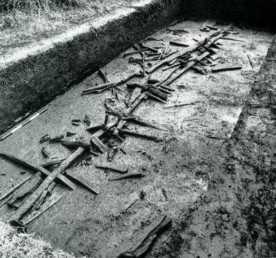
The Sweet Track was
a raised walkway, built about 3800 BC to cross nearly 2 km of
reed swamp that lay between dry land and a mid-marsh island. Its single plank
walkway was held about 40 cm above the soft ground surface by pairs and groups of
obliquely crossed pegs retained by a ground-level rail (plate 5.4). Oak, ash and lime
were used for planks, and almost all the common species of a mixed oak forest were
exploited for the pegs and rails. The straight uniform growth of much of the
roundwood used for these supporting timbers is indicative of coppiced growth, either
fortuitously sprung from the stumps of felled trees and shrubs or perhaps already
produced by some system of forest management akin to that practised by
contemporaries at Hornstaad-Hornle I. The external evidence for coppicing is
supported by analysis of the tree-rings, which has been particularly fruitful for the
Sweet Track (Morgan 1988). Oak, ash and hazel have all added to the understanding
of the structure. Hazel and ash growth patterns, like those of the oak, indicate that
the bulk of the wood was felled in one season and a few pieces were added as repair
timbers in the next 11 years, but no evidence has been found for repairs at a later
date. This suggests that the track was in use for a little over a decade, an
interpretation supported by examination of fungal attack on the wood, which was not
advanced.
The oak timbers used
for planks came from mature trees at least four centuries old,
except for a short stretch at the southern end of the track were split radially to provide
planks wide enough for the walkway (30-50 cm). The younger trees had to be split
across the centre to give planks of a similar width, and it is noteworthy that this could
be achieved with the technology of the time when timber-working depended on stone
axes and wooden wedges and mallets. The evidence for two stands of timber of
different ages implies mature primary forest on the central island and younger
woodlands at the southern end, with perhaps an early episode of forest clearance
followed by regeneration 120 years before renewed clearance took place to build the
trackway. The earlier clearance is not evident in the pollen record, but the one
associated with the track building can be identified. The indicators of cultivation are
stronger near the southern terminal of the Sweet Track than near the northern end
where it abuts the central island.
The reed swamp traversed
by the trackway was not altogether uniform. Analyses of
pollen, plant macrofossils and beetles from a central area (Caseldine 1984, Girling
1984) indicate particularly wet conditions, with an abundance of aquatic plants and
insects. There was also the raft spider (Dolomedes) which hunts small fish and
insects in permanent bodies of water. At this point the trackway substructure had
been reinforced during initial building, and repair wood was subsequently added. All
the signs are of a difficult area, although no evidence was found for special treatment
along the lines noted for the Wittemoor trackway.
The Sweet Track was
merely a footpath, barely 20-30 cm wide, stretching away
through high reed beds which masked the ends once a traveller had begun his or her
walk. Hazards of high water, obscuring reeds, slippery wet planks and projecting
pegs all combined to make the walkway precarious. Passing places for chance
encounters have not been found. Hence, along the line there is the debris of passing
traffic. Flint flakes, unmoved since loss and cushioned by the peat, lie along the track
sides. Some were used to cut wood, others for reeds and other plants, and a single
flake was used to cut hide. Arrowheads of flint point to hunting expeditions: traces of
glue or of arrowshafts or of binding string were preserved on several of them, and a
number of bow fragments were also recovered. A fine flint axe and a jadeite axe-
head were found beside the track timbers. These two unhafted unused axe-heads
suggest either accidental losses or deliberate acts of deposition for a purpose
unknown to us. Pottery found along the track included heaps of sherds making
almost complete pots, accidentally broken by clumsy travellers; in one case, a pot
had held hazelnuts, and in another a wooden spurtle or stirrer was being carried
along with, perhaps, gruel. Other artefacts round along the track line represent other
objects discarded during use in the swamp. Bows, digging sticks, spades or
paddles, wedges, handles, pins, a spoon, a mattock, a comb, toggles and a carved
bowl are in no way spectacular or even carefully fashioned; they are the common
variety of artefacts that have perished on contemporary dryland sites. Everything
found on, in or beside the track was contemporary. This is not archaeological
contemporaneity, which may with luck be only a century, but more likely a quarter
millennium in duration, but it is real time. Everything, artefacts of stone, flint, pottery,
wooden planks and pegs, the swamp teeming with wildlife, and the forests, fields and
coppices on the drey land around was in exi9stence and in operation all at one
moment in time. One group of unnamed Bronze Age people saw it and were a part
of it. They and their settlement perished, leaving only their footpath through the local
wilderness as witness to their presence. |
|
|
|
|
|