Rhos Llawrcwrt
National Nature Reserve (NNR) is an area of marshy grassland in mid
Ceredigion, west Wales. The site supports an internationally
important population of the marsh fritillary butterfly Eurodryas
aurinia, which in 2006 was one of the largest in the UK. The site
is located approximately 9km east of the coast and 1 km south-west
of the village of Talgarreg.
First mentioned in
1214 in a charter granted to the Cistercian monks of Whitland,
Llawrcwrt has been part of the local agricultural economy for at
least nine centuries and probably much longer. The site is typical
of many wet pastures in the county, having a long history of
extensive grazing by cattle, horses and sheep, but also some
cultivation, including planting of crops such as potatoes and black
oats (Robertson and Wheeler 2002). Agricultural practice, often ad
hoc in nature, has been fundamentally important in determining the
nature of flora and faunal communities that exist today. Influenced
by geology, geomorphology and other physical factors, this
management has led to the development of an open wetland landscape
relatively free of scrub and woodland. Llawrcwrt Farm first came to
the attention of local naturalists and the Nature Conservancy in
the early 1970s when it was recognised as an area of 'relatively
unmodified' marshy grassland with associated diverse ranges of
plants and invertebrates. Following further survey, part of the
farm was notified as a Site of Special Scientific Interest (SSSI)
in 1979, and in 1983 Grade 1 status in the Nature Conservation
Review was confirmed. At this time, it was clear that the marsh
fritillary population was the largest in the county and one of the
largest in the UK. Extensions to the SSSI followed, and in 1985 the
Nature Conservancy Council purchased most of the designated area,
which was declared an NNR in 1986. Since declaration, the SSSI and
the NNR have been further extended. The SSSI qualifying features
are:
Marshy
grassland
Neutral
grassland
Marsh fritillary
Eurodryas aurinia
Slender green
feather moss Hamatocaulis vernicosus
Rhos Llawrcwrt is a
Special Area of Conservation designated under the EU Habitats
Directive for its populations of marsh fritillary and slender green
feather moss Hamatocaulis vernicosus.
The NNR now covers a
total of nearly 66 ha and is divided into two sections separated by
about 200m of improved pasture. The western block covers 54 ha and
includes approximately 24 ha of rhos pasture and 26 ha of
agriculturally improved grassland. The eastern block, known as Cors
y Clettwr, covers approximately 12 ha, most of which is rhos
pasture.
An inspection of any
large-scale maps of south and west Wales will reveal that the word
'rhos' is a common component of many place names and has long been
associated with the 'bogs' in valley bottoms that were so
characteristic of the region. As an ecological term, rhos pasture
is used for a specific mixture of vegetation communities. In south
west England this mixture of communities is known as culm
grassland. The following are extracts taken from the English Nature
Wildlife Enhancement Scheme report Management Guidelines for Culm
Grassland (1991):
Culm Grassland is
not easy to describe in terms of better-known wildlife habitats
(which is why it has been given a name of its own), but in essence
is a complex of wet acidic grassland, wet heath, fen and mire
communities. Most sites contain several of these elements, each
grading into one another to form a close-knit mosaic of distinctive
appearance.
In strict
phytosociological terms, culm grassland (rhos pasture) is composed
of a variety of mire vegetation communities. However it is aptly
named 'Grassland' in lay terms because purple moor grass Molinia
caerulea is characteristically constant at a high percentage cover
and sites are traditionally grazed by domestic
livestock.
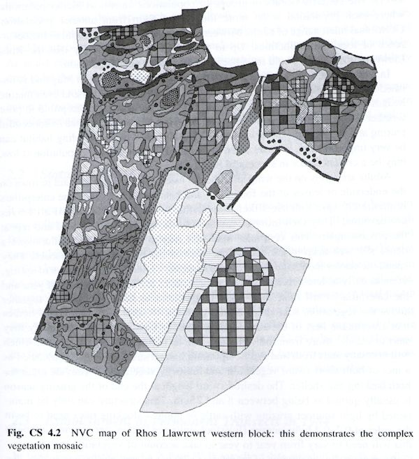
The reference to
'mosaic' in the English Nature definition of Culm grassland and the
NVC survey are particularly significant. The NVC map for the
western block of Rhos Llawrcwrt illustrates the fine scale of the
mosaic at this site (Fig. CS 4.2).