Christopher Taylor applied the term Mid Anglia to include most of the modern shire
lands of
Bedford, Cambridge and Northampton. These lands more or less formed the heartland of the
ancient Saxon kingdom of the Middle Angles There is no familiar name attached to this part of
England that is all too often traversed by people going elsewhere. It is also an ill-defined
topographical area sandwiched between the northern termini of the Cotswolds and Chilterns,
and the beginning of the Fens. It spans watersheds and catchments of the four major English
rivers; Trent, Welland, Great Ouse and Thames
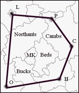
Mid Anglia is broadly defined topographically in Fig 1 as a polygon with its corners
on Leicester
(L), Peterborough (P), Cambridge (C), Hertford (H) and Oxford (O). It encloses an area about
100km north to south and 80 km east to west, and contains examples of the landscapes of 16
natural areas.
The region is centred on the West Anglian Plain natural area and the four natural
areas within
it; Midland Clay Pastures, Rockingham Forest, Yardley-Whittlewood Ridge and Bedfordshire
Greensand Ridge. The streams and rivers draining the heartland feed the Trent to the north, the
Welland and Ouse to the east, and the Thames to the south. The watershed straddles the
boundaries of the local authorities of Peterborough (P), Cambridgeshire (Cambs), Bedfordshire
(Beds), Buckinghamshire (Bucks), Milton Keynes (MK) and Northamptonshire (Northants).
Fig 1 The heartland of the West Anglian watershed
.
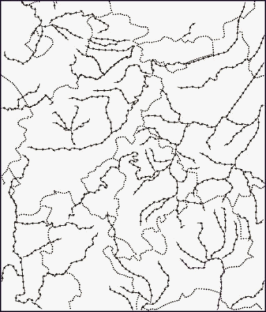
Fig 2 The river systems
of Mid Anglia
Arrowed lines represent main river systems
Dotted lines are county boundaries
One of the visions behind the UK strategies for sustainable development is the boost
to
concerted action that comes from the sharing of ideas and outcomes of conservation
management between organisations and communities. Nowhere could this be better
exemplified than in the region that defines Mid Anglia. It comprises several natural areas that
have been delineated to provide a landscape framework for conservation, which cut across
several local authority
boundaries. The national strategy for biodiversity is based on local
authorities as the reference points for the production of local biodiversity actions plans. Mid
Anglia therefore provides an ideal arena for comparing different approaches to the national
imperative of sustainability.
The starting point is to define the areas and their geology, then compare cross- authority
examples of biodiversity action plans and their local outcomes at the level of nature sites and
communities.