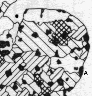
Fig
1 Pattern of rurality in East Anglia
A = Aldeburgh/Southwold
coast: for key to shading see Introduction/Lines and rurality. The blank areas
represent regions of extreme rurality.
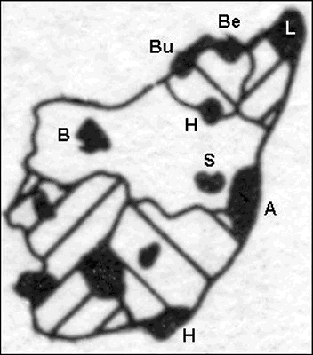
Fig
2 Pattern of rurality in Suffolk
Bu = Bungay; Be = Beccles;
L = Lowestoft; H = Halesworth; B = Bury St Edmunds; S = Saxmundham &
Kelsale; A = Aldeburgh & Southwold
It is generally accepted that the Hundred of Blything was a pre-Norman political unit
with its
administrative centre at Blythburgh. Its position at the head of the navigable estuary of the River
Blyth makes it an obvious point from which seaborne colonists could spread fan-like up its
tributaries. The settlement is in a key position in the eastern river system mid-way between the
north and south limits of the Hundred.
The first recorded tribal rulers of the hundred are the members the Wuffinga. This
family gave rise to
a dynasty of the Anglo Saxon Kings. The importance of Blythburgh as a royal manor is inferred
from records of early Christian tombs, and its selection as the burial place of the Christian King
Anna, in 654, and then for the burial of his son. Anna's lands stretched the entire breadth of Suffolk
from Blythburgh to Exning, and the Midlanders had to march to Blythburgh to defeat him.
In Domesday Book the Blythburgh glebe was described as the personal property of Edward
the
Confessor, when it was about ten times the size of the average for other Suffolk churches, The
property was inherited by William I, and the royal connection was continued into the 12th century
when Henry III founded an Augustinian priory on his Blythburgh lands. Discovery of the ship burials
at Sutton Hoo and Snape has focused attention on the Deben estuary as the invasion corridor.
However, Anna gave these coastal lands south of Blything, stretching between the rivers Alde and
Orwell, to endow his daughter's monastery at Ely. The gifting of this land on behalf of Etheldreda,
as the five and a half hundreds of Wicklaw, points to Blything as the heartland of the early Anglo
Saxons.
At the earliest point in their recorded history we only know of the hundreds by their
names. Their
importance to the Saxon administration is clear from the way the hundreds were used to categorise
the Suffolk manors in the Domesday Book, and it is clear that the same groups of communities
related to the hundred from then on, down to modern times, as units of local government.
It was not until the advent of map making in the 18th century that we can visualise
the position of
the boundaries running between settlements. The first county map showing Suffolk's hundred
boundaries is that of Hodgkisson in 1783. The following investigation takes Hodskinson's map as
the starting point for an analysis of the history of land management in relation to special features
of
the Hundred boundary.
Click here to go the the special features section
Not yet available