Blything is the largest of the Suffolk hundreds, the area amounting to almost nine
times that of
Thredling, the smallest (Table 1). Of the three coastal hundreds it has the largest shore line (8
parishes). The village of Blythburgh is the probable original meeting place of the Hundred Court, at
the head of the wide estuary of the River Blyth. The hill above the river crossing where the parish
church now stands, was the site of a medieval priory, and is a likely spot for the Moot Hall. It had
an important religious significance for the first Christian monarchs of East Anglia, notable King Ana
of the Wufinga dynasty. In this respect, the Anglo Saxon name ‘Blything’denotes
the territory of the
‘people of the Blyth’.
Table 1 Areas of Hundreds 1855 (Whites Directory 1925)
|
Name
|
Acres 1855
|
Acres 1925
|
1855-1925
|
1855 ratio to
Thredling
|
|
Bury St Edmunds
|
2,939
|
|
|
|
|
Ipswich
|
7,020
|
|
|
|
|
Thredling
|
9,943
|
9,943
|
0
|
1
|
|
Colneis
|
20,766
|
18,131
|
2,635
|
2.09
|
|
Stow
|
21,965
|
21,965
|
0
|
2.21
|
|
Carlford
|
27,233
|
27,539
|
-306
|
2.74
|
|
Cosford
|
30,532
|
30,532
|
0
|
3.07
|
|
Loes
|
30,859
|
30,933
|
-74
|
3.10
|
|
Thingoe
|
31,114
|
31,114
|
0
|
3.13
|
|
Wilford
|
33,012
|
33,357
|
-345
|
3.15
|
|
Wangford
|
35,079
|
33,187
|
-1892
|
3.53
|
|
Mutford &Lothingland
|
35,490
|
33,315
|
-2175
|
3.57
|
|
Thedwestre
|
40,451
|
40,851
|
0
|
4.07
|
|
Plomesgate
|
45,389
|
46,211
|
-822
|
4.57
|
|
Bosmere &Claydon
|
49,331
|
48,159
|
-1172
|
4.96
|
|
Samford
|
50,230
|
48,549
|
-1681
|
5.05
|
|
Hartismere
|
54,215
|
50,088
|
-4127
|
5.08
|
|
Hoxne
|
56,625
|
55,563
|
-1062
|
5.70
|
|
Risbridge
|
61,183
|
59,762
|
-1376
|
6.15
|
|
Blackbourn
|
63,875
|
65,352
|
-1477
|
6.42
|
|
Babergh
|
73,428
|
71,813
|
-1615
|
7.38
|
|
Lackford
|
77,025
|
77,159
|
-134
|
7.75
|
|
Blything
|
88,507
|
87,941
|
-566
|
8.90
|
The central area of the hundred embraces the complex watershed of the River Blyth.
Its coastal
limits are on the North and South Hundred Rivers. The hundred also takes in villages on the minor
watersheds of the Yox- Minsmere River, and the Easton River (Fig 1).
Fig 1 Parishes of Blything Hundred: pre 1855
Starting from the North Hundred River, the boundary runs across the sources of the
Easton River
and the River Yox eastwards to the glacial Till Plain, which separates the coastal drainage of
Suffolk from that of the Waveney. It then skirts the headwaters of the Blyth at a height of about 50
meters, turning back to the coast along the southern edge of the Yox-Minsmere valley, crossing to
the watershed of the South Hundred River to reach the sea at the marshes of Thorpeness. All these
rivers cut their way to the sea through the glacial outwash of the ‘Sandlings’.
Of all the Suffolk
hundreds it is the one that is most clearly delineated by the primeval topography, a characteristic
indicative of an early tribal origin.
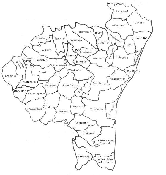
The hundred boundary of Blything is shared between 21 peripheral parishes (Fig 2),
which abut on
four other hundreds. From north to south, these hundreds are Mutford & Lothingland, Wangford,
Hoxne and Plomesgate. There are altogether, 26 parishes in these three hundreds that border on
Blything.
Fig 2 Blything Hundred boundary parishes pre 1855.