|
A Quest for Rurality Following the
Hundred Boundaries of Suffolk
Denis Bellamy & Ruth Downing
Hundred boundaries; Hodskinson (1783)
Background
Most people like the countryside and have
no problem in defining what they like about a rural
environment. Furthermore, they would support countryside
management to maintain its value features. Difficulties
arise in managing rurality because there is no single
set of features that appeal to everyone. For example,
an agricultural value differs from that perceived by
tourists, a wind turbine is not acceptable, but a wind
mill enhances the view.
A definition of rurality depends on:-
the functions designated to the countryside;
historical notions
about the countryside that encapsulate what it was like
at a particular point in time;
spatial differences
in landscape between different parts of the country,
according to geography and scale.
During the last forty years the approach to
managing rurality has been to define compatible goals
and devise an integrated plan that reconciles the different
objectives. The designation of 'Areas of Outstanding
Natural Beauty (AONBs)' brought these management problems
to a head. Now the idea is growing that the drawing
of statutory boundaries to facilitate top-down management
of rurality inevitably encourages the belief that outside
the 'fence' anything goes Also, top down management
is giving way to stakeholder involvement at the grass
roots. A separative professional culture of planners
and planning not only impedes the sharing of lessons,
it also locks away knowledge about how people can discover
vernacular heritage in private ownership and mount a
family or community plan for its year on year management,
protection and promotion. It is therefore important
to explore ways of making the ideas and practices of
professional conservation management more accessible.
In this context, a view is gaining ground within the
parks and protected areas movement to encourage the
uptake of stewardship by communities. The aim is to
promote environmental management by stakeholders, and
put a relevant planning process at the heart of the
community and its local economy. This approach is also
relevant to encourage communities within protected areas
to take responsibility for their own patch in the conservation
mosaic of the wider area. The hope is that local conservation
management will become a corner stone to build a sustainable
livelihood.
There are several starting points to investigate
management of the countryside and this approach, called
'Hundred Lines', takes the view that an intuitive start
to make a place special is to define a notional line
around it that encompasses its past, and sustain continuity
between past and present users of the settlement space.
This is how parish boundaries originated, and a sense
of place in history was rejuvenated year by year when
members of the community walked their bounds. Although
parish boundaries are still the basis of community governance
and local planning issues, few parishioners would be
able to map their limits. Still less would they be aware
of this ancient line as a container of rurality and
its heritage that could help them focus environmental
management of their special place in relation to the
wider world.
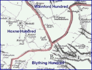
A 'Hundred Line' is made by connecting up
the community boundaries of English parishes at the
edges of ancient administrative divisions known as Hundreds.
As notional entities they are over a thousand years
old and traverse the landscape in remembrance of the
socio- economic parcellation of land that followed early
tribal settlement. Their modern relevance is that they
have often been used since to define boundaries of district,
county, and parliamentary constituencies. A Hundred
boundary is therefore a long-distance notional pathway
for the mind to explore the history of land management.
We authors of 'Hundred Lines' have been committed
for many years to the promotion of research into rurality
and its use as a framework for education and local environmental
management. We both have deep ancestral roots in Suffolk's
Hundred of Blything, an ancient tribal area that cannot
be surpassed in its models of environmental issues.
These range from the notions about free men and women
of the sustainable economy of Domesday to the fears
attached to the nuclear power station that marks its
southern boundary at Sizewell. Blything is also ordinary.
Although situated in one of the few areas of extreme
rurality, it is not an AONB although its planning issues
are the same.
We believe that a Hundred Boundary, like Hadrian's
Wall, can be developed as a educational scaffold to
promote involvement with local heritage as an essential
investment for sustainable development. It is a mapping
thread that links nature with the historical design
of landscapes in the context of contemporary plans for
the integrated management of nature and rurality. |


