The Hundred of Blything occupies seven river systems that have carved a broad arc
into the plateau
clay of High Suffolk. The plateau is its highest (about 55 metres), and flattest, at the watershed that
separates Ubbeston (Blything Hundred) from Laxfield (Hoxne Hundred). In general the Hundred
boundary follows the high land between rivers and streams, but at some places it follows streams
(becks). The western valleys descending from the boundary settlements have relatively steep sides
into which minor roads follow narrow gullies. Some of these gullies (locally named 'Gulls') probably
represent old melt-water channels of the last glaciation. In relation to their size the valleys are
occupied by relatively small streams, an indiation that they were cut by by the flows of much larger
volumes of water in the past. Again this is characterisitic of a late glacial landscape.
Towards the coast the streams run through sands and gravels (the Sandlings) which
probably
respresent the outwash of glacial flood waters. The outlets to the sea are often blocked by shingle
bars, and are separated from one another by soft cliffs undegoing rapid erosion.
Occasional woods, copses, small fields and tree lined hedgerows, considerably enhance
the local
character, particularly in the west where vast treeless vistas have resulted from the removal of old
hedgrows.
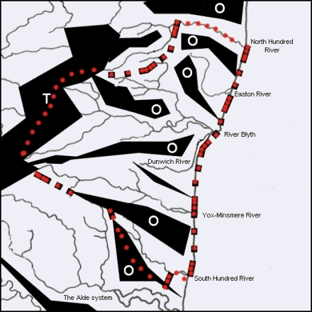
The general topography of the Hundred is presented diagramatically in Fig 1.
Fig 1 Topographic diagram of Blything Hundred.
Black areas delineate watersheds
T = Glacial till plateau
O = Outwash sands and
gravels
The course of the Hundred
boundary is indicated in red.
The Hundred boundary provides a commentary on thefollowing 6 landscape categories
Estuarine marshy pasture
Sandy arable with plantation woodland and forestry
The becks and their narrow flood plains
Trees in claylands
Upper valley routways
Light arable plaeau clays
Heavy arable plateau clays
Common land
Community
Buildings as visual heritage
Scenes of work and recreation
Botanical microcosms
Earthworks