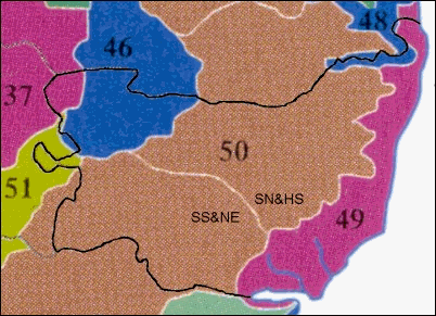
Fig 1 The county of Suffolk as a composite of six Natural Areas and two Character
Areas
Natural Areas
37 = The Fens; 46 = Breckland; 48 = The Broads; 49 = Suffolk Coast and Heaths; 50
= East
Anglian Plain; 51 = East Anglian Chalk.
Character Areas
SN&HS = South Norfolk and High Suffolk Claylands; SS&NE = South Suffolk and
North Essex
Claylands.
Much of our biodiversity depends upon the broad character of whole landscapes, rather
than the
isolated ecosystems of a small number of closely defined and protected sites. Wildlife is not
restricted to designated and protected sites such as nature reserves or SSSIs; it occurs throughout
the countryside, coast and built up areas. Administrative boundaries, such as County boundaries,
are irrelevant to wildlife and natural features. No part of the country is without some wildlife interest.
To translate this reality into an appropriate knowledge framework for comprehensive local action a
key component of England’s nature conservation strategy for
the 1990s was the ‘Natural Areas’
approach. The countryside was divided up according to the characteristic wildlife and natural
features. These 120 areas of local distinctiveness defined a series of Natural Areas with boundaries
based on the distribution of wildlife and natural features, and on the land use pattern and human
history of each area. The viewpoint was that the uniformity these areas offered was a more effective
knowledge framework for the integrated top-down and bottom-up planning and achievement of
nature conservation objectives than do areas contained within administrative boundaries. In
particular the Natural Areas approach appeared to give a new way of determining priorities for
nature conservation in areas with ecological and landscape integrity, and to set objectives which
reflect these priorities across administrative boundaries and organisations.
The East Anglian Plain occupies the centre of East Anglia, and is an example of a
natural area
defined by its uniform cover of glacial clays, which until now has received little recognition.
Adjacent natural areas, such as Broadland or Breckland, have long had public recognition. The
natural areas concept encourages a focus on all parts of the country because all natural areas have
their own characteristic wildlife features, even though some natural areas are richer in wildlife than
others.
Area Profiles
After a wide range of local consultations on the boundaries of the Natural Areas themselves
and
what should be used to define their distinctive character, a profile of each area was published. A
profile describes the wildlife and natural features of a Natural Area, and what makes it special and
distinctive. It therefore includes nature conservation objectives that are particular to the area.
Essentially, a natural area is a part of the country that has a unique combination of natural features
and land-use, mainly influenced by landform, climate and soils.
Using natural areas, we can more easily identify common processes, issues and trends
affecting
each aspect of the natural resource and decide how we want to conserve it. The natural area
framework helps us to strive towards conservation within the whole landscape, moving outwards
from the current focus on small areas with high concentrations of wildlife. At a practical level,
management know how about a particular feature should be more easily transferrable from site to
site within a Natural Area.
The Natural Area System in Strategic Planning
The practical aims of a profile are to influence nature conservation actions for the
foreseeable future
by:
providing an analysis
of the current extent of the conservation resource, the changes that
have occurred, and trends that are influencing the resource.
highlighting threats and
issues; ie the factors that have to be addressed by conservation
managers
setting strategic objectives
for the conservation of large tracts of wildlife and natural
resources. These objectives are intended to be wide-ranging and visionary. If they are all
achieved, then the needs of nature conservation will be achieved. The objectives are for the
whole conservation community, and for the wider community who influence land
management and land-use. Some objectives may be achievable by conservationists in the
short-term. Other objectives may take a long time to achieve, and will require change in
other sectors, such as agriculture.
Character areas
The Natural Area concept includes local people's recognition of the area. People are
stakeholders
in local wildlife because plants, animals and natural features have developed within their
community’s culture and history. Although generally the wildlife
and natural features of Natural
Areas are elements that people recognise as being distinctive, sometimes the local recognition of
the impact of history and culture require Natural Areas to be subdivided or combined to make them
socially meaningful. These areas with a particular cultural unity are described as Character Areas.
For example, the London Basin is a Natural Area divided into seven Character Areas; the East
Anglian Plain is also a Natural Area divided into three Character Areas.
The Local Heritage Resource
With regard to conservation action plans, the operational component of a Character
Area is a
landscape that can be identified by local people as a heritage resource. This is usually their local
community, but larger socially meaningful landscape heritage units may emerge based on river
valleys or watersheds that contain parts of more than one Natural Area. The Blything Hundred is an
example of the latter, being a well documented ancient tribal settlement area of East Suffolk. It is
contained within the watershed of the River Blyth, and some smaller streams, draining the eastern
edge of the High Suffolk Claylands Character Area. This distinct drainage system reaches the sea
through the Suffolk Coasts and Heaths Natural Area
Therefore, a Natural Area profile does not set precise targets for any parts of the
conservation
resource. It prescribes no actions, contains no work programmes, nor has timescales for
achievement. It simply sets a uniform knowledge framework for current and future action. New
action plans or programmes, for particular species, habitats or organisations, may be drawn up as
a result of the analyses in a profile, but they will not become part of that profile. They will be
management plans for specific places within a Natural Area. The local targets will be ecologically
relevant, by being based on an understanding of the Natural Area's resource and objectives.
However, the administrative framework for action remains based on Local Authority areas, as many
other organisations use those boundaries (e.g. County Wildlife Trusts, FWAG). For example, the
Suffolk Biodiversity Action Plan will include elements from the natural area-based targets for all the
natural areas in Suffolk, to be worked upon using Suffolk as the implementation unit.